Connectivity concept in karst: the doline-cave coupling in the context of human impacts
Principal Investigator at ZRC SAZU
Mateja Breg Valjavec, PhD-
Original Title
Koncept soodvisnosti v krasu: povezanost vrtač in jam z vidika antropogenih vplivov
Project Team
Jure Tičar, PhD, Matija Zorn, PhD, Rok Ciglič, PhD, Mauro Hrvatin, PhD, Mateja Ferk, PhD, Matej Lipar, PhD, Prof. Andraž Čarni, PhD, Stanka Šebela, PhD, Aleš Smrekar, PhD, Mateja Breg Valjavec, PhD, Špela Čonč, Matjaž Geršič, PhD, Katarina Polajnar Horvat, PhD-
Project ID
J6-2592
-
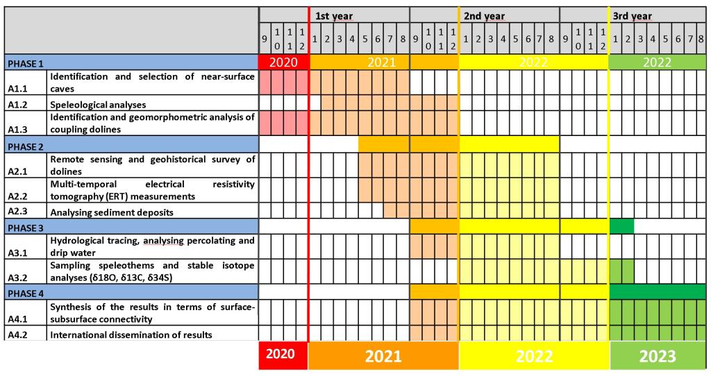
Duration
1 September 2020–31 August 2023 -
Project Leader
dr. Mateja Breg Valjavec
-
Financial Source
ARRS - Javna agencija za raziskovalno dejavnost

Partners
Znanstvenoraziskovalni center Slovenske akademije znanosti in umetnosti
Karst landscape represents approximately 8.800 km2 or 44 % of the Slovenian territory and consequently about half of the population depend on it as a source of drinking water. It is estimated that pressure on that source will rise. Despite the vulnerability of karst due to its low filtering capabilities in karst aquifers, karst landscapes experience more pressure due to the intensification of human activities. Among others, they have developed exceptional geomorphological features such as dolines and caves.
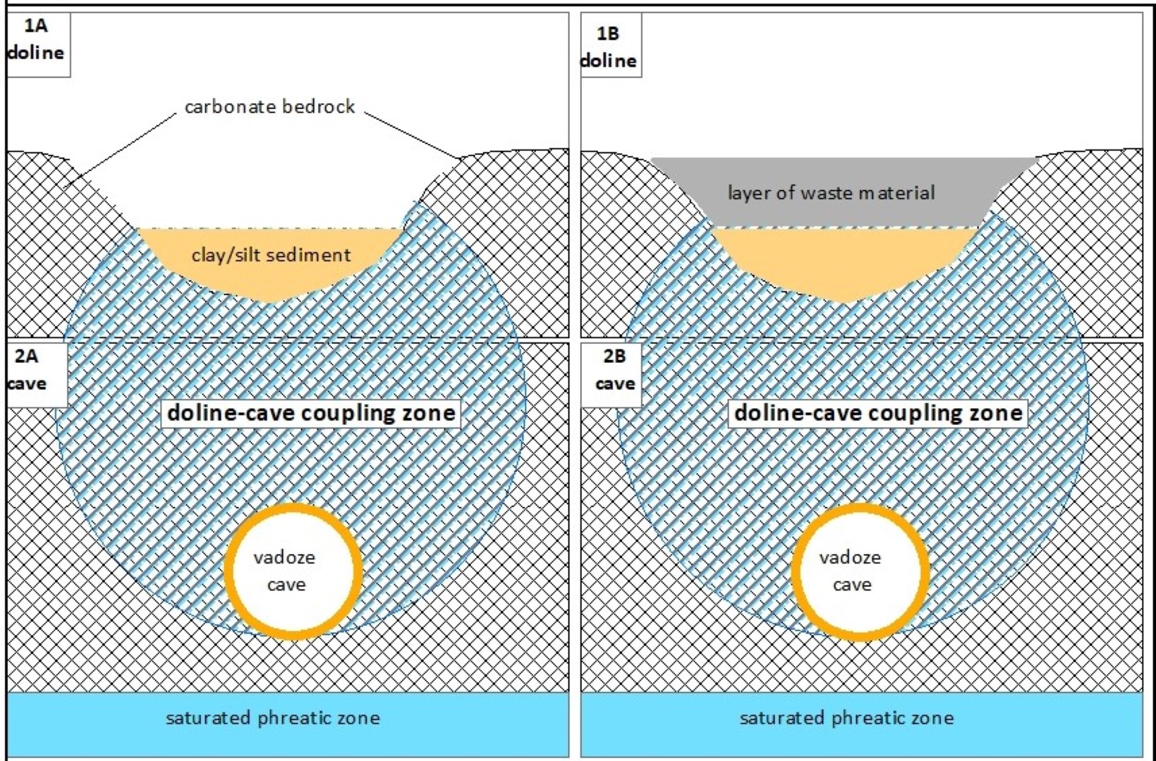
Geoscience has been devoting increased attention to understanding the complex pathways and flows of material, energy, and the multidimensional coupling between various geological systems. This understanding includes the “concept of connectivity”, which provides an overall framework better to investigate how the function of different drainage systems. Within this project, we aim to connect both of these karst formations, where our main interest is a direct flow between dolines and caves. Dolines represent our research “input points” and the caves directly beneath them as our research “output points”. In relation to the concept of connectivity between the karst surface and subsurface, hydrological, sediment, and geochemical connectivity’s are the most relevant.
By comparing the dynamics between the surface terrain (e.g., depressions, flat plateaux) and the subterranean space (caves) over a long period of time, we can explain the natural processes in relation to the palaeoenvironment and the extent of human influence.
Our purpose is to determine the role of sediment in the dolines for the hydrological and geochemical connectivity of dolines with the near-surface caves in the vadose zone by following specific objectives:
- Objective 1: Asses the near-surface caves and dolines in the research area of low Dinaric Karst Plateaus (for example Kras Plateau, Matarsko podolje Plateau, Gorjanci Hills); find the appropriate dolines above caves for further analysis of human impacts.
- Objective 2: Identify the presence, extent and characteristics of connectivity in doline-cave coupling zone for three representative near-surface caves of low karstic plateaus in the Dinaric Mountains.
- Objective 3: Analyse geomorphological characteristics of selected dolines.
- Objective 4: Identify characteristics of sediments in dolines and near-surface caves and the geochemical parameters of infiltrating water (on the surface/doline and in near-surface caves) to determine human impacts from the specific doline.
- Objective 5: Define the influence of sediment characteristics on processes and features in the epikarst.
- Objective 6: Build and test the transferable impact risk assessment model of doline-cave coupling zone, considering near-surface caves.
We represent objectives and related preliminary results.
OBJECTIVE 1: DETERMINE NEAR-SURFACE CAVES IN THE VADOSE ZONE AND APPROPRIATE DOLINES FOR FURTHER ANALYSIS OF ANTHROPOGENIC IMPACTS
We identified near-surface caves and dolines lying above them. We created a data layer of all detected near-surface caves and a layer of connected dolines in selected Slovenian regions (Kras, Matarsko podolje and Logaško-begunjski ravnik plain). The research took place in the archive of the Cadastre of Caves of the Cave Association of Slovenia, geoinformation measurements and analyses were carried out in the office, with the analysis of Lidar DTM (1m x 1m) and satellite / aerial images, and field research work was carried out both in caves and on the karst surface. We chose 3 caves at the level of Slovenia. The evaluation criteria were the depth of the vadose cave <100 m; cave length >200 m; altitude of the cave entrance <1000 m above sea level; the ratio between depth and length of the cave is < 0.5. Out of 13,659 karst caves (Kadaster jam, 2021), we selected 264 (only 1.9%) suitable for further analysis in 6 regions: Matarsko podolje, Notranjsko podolje, Pivško podolje and Vremščica, Karst, Bela krajina, Krimsko hribovje and Menišija). For 103 selected caves, the maps from the Cadastre of Caves were scanned, vectorised, georeferenced and covered with the surface on Lidar DTM. We narrowed down the selection of caves to 32, and with an expert decision we chose 3 caves: Polina peč (cat. no. 938) in Matarsko podolje and Divaška jama (cat. no. 741) and Jama pri Ukmarjevem dolu (354) in the Kras Plateau.
We identified karst dolines and performed a geomorphometric analysis in three areas (Kras Plateau, Matarsko podolje plain, Logaško-Begunjski ravnik plain). The results are presented in the journal Remote Sensing in a paper titled The impact of digital elevation model preprocessing and detection methods on Karst depression mapping in densely forested Dinaric mountains.
We carried out a geohistorical analysis of dolines land-use changes using the Franciscan Cadastre from 19th century, Lidar DTM and aerial images, and mapped all dolines and extracted cultivated dolines. For the Logaško-Begunjski plain, we evaluated the use of dolines from the point of view of ecological function for the preservation of the microhabitat of large animals and published the results in the journal Remote Sensing in a paper entitled Dolines and cats : remote detection of karst depressions and their application to study wild felid ecology
OBJECTIVE 2: IDENTIFY THE EXISTENCE, EXTENT AND CHARACTERISTICS OF THE CONNECTIVITY PROCESSES IN THE DOLINE-CAVE COUPLING ZONE FOR THREE REPRESENTATIVE NEAR-SURFACE CAVES.
Schematic representation of the connectivity between a doline and a cave in the vadose zone.
In the area of three study caves, we are investigating hydrological, geomorphological and ecological processes and phenomena in dolines on the surface and in cave tunnels. We performed a high-resolution (2 cm) terrestrial 3D laser scanning (Leica BLK2GO) of the caves and created a 3D model for each one, determined the position, depth and geomorphology of the cave.
In 2022, we presented the preliminary results for the Polina peč cave at the International Karstological School, at the World Geomorphological Congress and at the biennial symposium Geographic Information Systems in Slovenia with the scientific publication of a paper in the proceedings of the symposium entitled Determining the geomorphological and hydrogeological connections between dolines and the cave Polina peč using 3D laser scanning
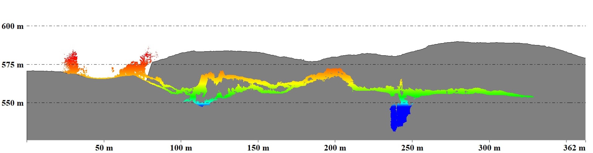
On the basis of 3D models, we carried out structural-geological mapping of the surface and the cave and started with the monitoring and recognition of flow patterns and hydrological connectivity in connectivity zones using indirect water tracking methods. In Divaška Cave and the Polina Peč cave, we installed 6 drip-counters with which we will ensure long-term flow measurements and tracking of rainwater through the vadose zone. On the surface of the Polina peč cave, we set up two measuring stations for monitoring the amount of precipitation, temporal high-resolution measurement of moisture and temperature in the sediment (<1 m).
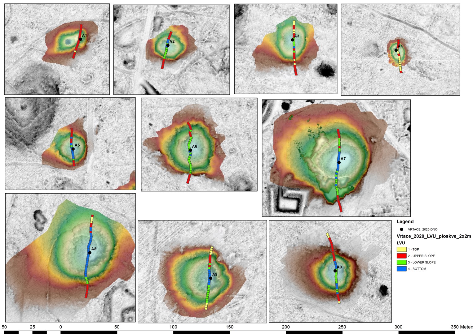
Based on the study of the latest international literature and on the basis of preliminary hydrological measurements of the seeping water in the Polina peč cave, we also considered the role of forest vegetation in the connectivity research, especially the role of trees whose roots penetrate deep into the epikarstic / vadose zone. Vegetation is also taken into account in the established concept of the karst critical zone, which further proves the necessity of its inclusion. As in the caves, we also performed high-resolution 3D laser scanning of the relief and vegetation on the surface using the same terrestrial scanner (LiDAR). We performed terrestrial 3D laser scanning of 20 dolines from which we are currently making accurate 3D terrain models. So far, we have carried out precise phytocenological field surveys in 20 dolines in the Kras Plateau. The results of electrical resistivity tomography measurements were used to investigate geomorphological and hydrological processes in relation to ecological processes in dolines. We used the vegetation as a proxy and as an indirect indicator of the ecological conditions in the dolines and determined the landform vegetation units. The results were published in the journal Ecological Indicators in a contribution Landform-vegetation units in karstic depressions (dolines) evaluated by indicator plant species and Ellenberg indicator values.
The figure shows 10 case study dolines, of different sizes and represents landform-vegetation units in the scale of 2mx2m continuous plots of along north-south transect.
OBJECTIVE 3: ANALYZE THE GEOMORPHOMETRIC CHARACTERISTICS OF THE RELEVANT DOLINES
The regional analysis was carried out on the basis of LiDAR DTM 1x1m and was completed for 3 study regions. We found out that the caves in the Kras Plateau and Matarska podolje plain are useful for the evaluation of anthropogenic impacts due to past activities. The results are presented in the journal Remote Sensing in a paper titled The impact of digital elevation model preprocessing and detection methods on Karst depression mapping in densely forested Dinaric mountains.
OBJECTIVE 4: IDENTIFY CHARACTERISTICS OF DOLINE SEDIMENT-FILS, CHARACTERISTICS OF SEDIMENTS IN NEAR-SURFACE CAVES AND THE ROLE OF DOLINE SEDIMENT-FILLS IN RELATION TO ANTHROPOGENIC IMPACTS.
Sediment-fills are not only at the bottom of dolines, but due to the genetically different types of dolines (e.g. the presence of denuded caves), they also appear on the slopes and outside of dolines. The clastic sediments at the bottom of the dolines were sampled up to 1.5 m depth. According to Grun (2002), thick accumulations of terra-rossa-like material in the bottom of karst basins are pedosedimentary complexes of polygenetic origin, so we accepted this term. The structural, textural and geochemical properties of pedosediment were analyzed in the laboratory of the Department of Forest Ecology at the Forestry Institute and in the Pedological Laboratory of the Faculty of Biotechnology, while mineralogical and micro-structural properties were analyzed at the Geological Institute. Sampling of clastic sediments in the caves is ongoing. For the selected dolines in the Kras Plateau, in addition to the inorganic parameters of pedosediments, we also investigated their ability for organic carbon sequestration, and will use soil organic carbon as a trace element in connectivity with the cave. Preliminary results for the Kras Plateau area were published in the journal Catena in a paper entitled Soil organic carbon stock capacity in karst dolines under different land uses.
OBJECTIVE 5: DETERMINE THE INFLUENCE OF DOLINE SEDIMENT-FILLS ON THE RECENT PROCESSES AND CHARACTERISTICS IN THE EPIKARST ZONE
Objective 5 will be achieved when the necessary research results presented in Objective 4 for all 3 study caves are collected. Based on the synthesis of the results of hydrological, geomorphological and ecological processes, we will present the role of doline-sediment fills on processes in the epikarst zone. So far, we have determined the extent and depth of the epikarst zone using electrical resistivity tomography measurements. At the Polina peč cave, the shallowest tunnel of the cave is 7 m below the surface, we detected tree roots in part of the tunnel, which proves that parts of the cave are in the epikarst zone, and the cave will serve as a good model for exploring the epikarst zone in-situ also underground.
OBJECTIVE 6: BUILD AND TEST A TRANSFERABLE IMPACT ASSESMENT MODEL BETWEEN DOLINES AND NEAR-SURFACE CAVES
Based on the case study of the Polina peč cave, we set up a preliminary impact assessment model for assessing the impacts between dolines and near-surface caves. The model is being tested on the example of the Divaška Cave and the Jama v Ukmarjevem dolu Cave. Usability and transferability are tested considering the depth of the cave tunnels, the geological base in which the dolines and the cave were created, differences in the vegetation above the cave and differences in anthropogenic activities in dolines. In the entire area of the Kras Plateau and the Matarska Podolje plain, we have determined cultivated dolines, in which there were fields and gardens in the past, dolines with lime-kilns and dolines filled with waste (landfills). Next to the Divaška Cave, we recorded a waste disposal site in the doline, the indirect influence of which is possible on the cave environment and will be determined through the on-going research. Above Divaška cave and Polina peč cave, there are abandoned lime-kilns in two dolines, whose direct connection with cave tunnels is still being investigated.